ครั้งแรกกับภาพถ่ายดาวเทียมตรวจวัดก๊าซมีเทนในชั้นบรรยากาศ

เป็นที่เราทราบกันดีอยู่แล้วว่า ก๊าซมีเทนเป็นก๊าซเรือนกระจกที่สำคัญอันดับสองในชั้นบรรยากาศ แต่ที่สำคัญไปกว่านั้นคือก๊าซมีเทนสามารถดูดซับความร้อนจากดวงอาทิตย์ได้มากกว่าก๊าซคาร์บอนไดออกไซด์ ๓๐ เท่าของปริมาณที่ใกล้เคียงกันและมีส่วนทำให้อุณหภูมิเฉลี่ยของโลกสูงขึ้นอย่างมีนัยยะสำคัญเป็นอย่างมาก ในขณะที่การปล่อยก๊าซคาร์บอนไดออกไซด์เพิ่มขึ้น แต่ก็มีงานวิจัยใหม่จากนักวิทยาศาสตร์กล่าวว่า เรากลับไม่ได้คำนึงถึงการเพิ่มขึ้นอย่างรวดเร็วของก๊าซมีเทนมากเท่าที่ควร ซึ่งมีการศึกษาพิสูจน์แล้วว่า การปล่อยก๊าซมีเทนในปัจจุบันนั้นเกิดขึ้นเร็วกว่าที่ระบบธรรมชาติจะสามารถกักเก็บไว้ได้

ดังนั้นในปัจจุบันทั้งรัฐบาลภาครัฐและเอกชนในหลายประเทศจึงพยายามพัฒนาเทคโนโลยีดาวเทียมเพื่อติดตามก๊าซมีเทนได้อย่างแม่นยำมากขึ้น ด้วยการใช้ภาพถ่ายดาวเทียมให้สามารถค้นหาแหล่งที่มาของการปล่อยก๊าซบนโลกนี้ได้

บริษัท GHGSat ซึ่งเป็นบริษัทจากประเทศแคนาดาเป็นบริษัทแรกที่สามารถถ่ายภาพจากดาวเทียมเพื่อตรวจจับการปล่อยก๊าซเรือนกระจกจากโรงงานอุตสาหกรรม ซึ่งรวมข้อมูลจากดาวเทียมตรวจจับก๊าซมีเทนขนาดเล็กสองลำโดยความร่วมมือจาก Sentinel-5P ของ European Space Agency และ EU

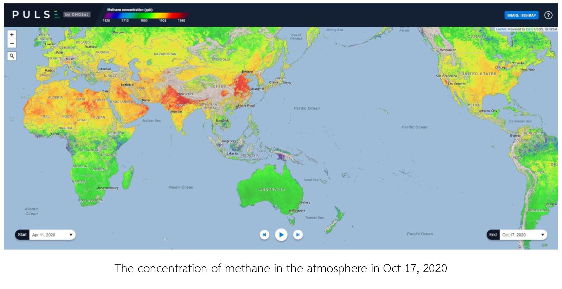
GHGSat ได้สร้างเว็บไซต์สำหรับประชาชนทั่วไปในการตรวจสอบการปล่อยก๊าซมีเทนแบบโต้ตอบแบบเรียลไทม์ที่ https://pulse.ghgsat.com/ ซึ่งจะมีการอัปเดตทุกสัปดาห์

การถ่ายภาพผ่านดาวเทียมเป็นเครื่องมือที่ดีในการช่วยให้เราประยุกต์ใช้และวิเคราะห์ข้อมูลเพื่อให้บรรลุเป้าหมายและการดำเนินการเพื่อลดการปล่อยก๊าซมีเทน และนอกจากนี้หน่วยงานของรัฐยังสามารถใช้ข้อมูลในการตัดสินใจและพัฒนานโยบายใหม่ในการลดก๊าซเรือนกระจกและพลังงานในอนาคต


ที่มา/แหล่งข้อมูล

  1. GHGSat Website: https://www.ghgsat.com/
  2. https://pulse.ghgsat.com/
  3. https://www.ghgsat.com/claire-iris-comparison/
  4. https://www.bbc.com/news/science-environment-54597764

Write a comment

Satellite Pictures made Methane Emitters Nowhere to hide

As we are already aware that methane is the second most important greenhouse gas emissions in the atmosphere. It effectively absorbs heat from the sun more than carbon dioxide 30 times as much as similar volumes and contributes the warming atmosphere significantly. While carbon dioxide emissions are increasing, there is a new research from scientist mentioned that we have failed to take into account the rapid rise in methane which is faster that it can be stored by natural sink.

Therefore, nowadays, both the governments, public and private sectors in many countries have developed satellite technology to track methane more accurately. Using this high-tech satellite-imaging, we can find emission sources on this planet.

GHGSat, Canada-based company is the first satellite that can detect greenhouse gas emission from industrial facilities, which combines data from two small methane-detecting spacecraft with collaboration from the EU and European Space Agency’s Sentinel-5P. GHGSat has already established the website for public people to interactive monitor methane emission in real time at https://pulse.ghgsat.com/, which will be updated weekly.

Satellite-imaging is a good tool on helping us to apply and analyze information to achieve targeted action and operation for reducing methane emission. Besides, government agencies can also use information to make decisions and develop a new policy on greenhouse gas reduction and energy in the future.


Reference

  1. GHGSat Website: https://www.ghgsat.com/
  2. https://pulse.ghgsat.com/
  3. https://www.ghgsat.com/claire-iris-comparison/
  4. https://www.bbc.com/news/science-environment-54597764
Write a comment